About Rivers & Seas
The chart plotter with AIS for inland waters. Rivers & Seas is the iPad navigation system for your boat: DETAILED WATERS MAPS Rivers and waterways are listed in detail with buoys, clearances, landmarks, ports and...
The chart plotter with AIS for inland waters. Rivers & Seas is the iPad navigation system for your boat:
DETAILED WATERS MAPS
Rivers and waterways are listed in detail with buoys, clearances, landmarks, ports and anchorages. In addition landscape, roads and buildings provide orientation. Marinas are shown with piers and service facilities such as gas stations and black water extraction.
AREA GUIDE
VHF channels, phone numbers and opening times of locks and bridges ahead are displayed automatically when driving. You will get a warning if a bridge clearance is too low or a lock will be closed upon arrival.
The display of speed, heading and position also includes the speed limit at the current route segment. Your location is named with river kilometer and name of the river, lake or bay.
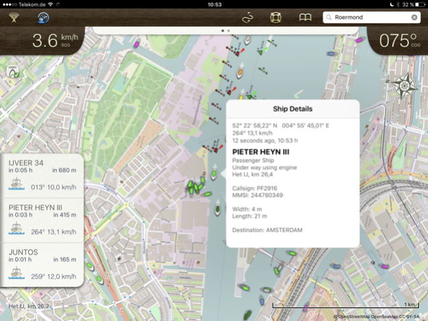
SHIP POSITIONS AIS (In App Subscription)
Position of ships with AIS is shown in the map. Ships on the waterway ahead are displayed in the left panel with name , course and speed. No AIS receiver is needed for that.
PLANNED ROUTES
Planned routes can be drawn and used as a guide line for the ride. Rivers & Seas calculates length and travel time of the route. The drawing tool is ideal for routes along winding waterways and chains of lakes.
The planned routes are also ideal on boating holidays for remembering and following the recommendation of a charter basis.
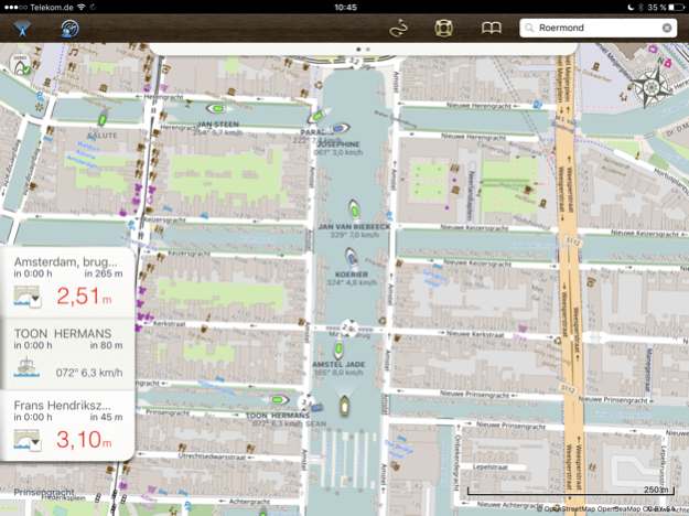
DESTINATIONS AND BOOKMARKS
Rivers & Seas predicts distance and travel time to destinations on the waterway that you mark with pins. The passage time and opening times of locks or bridges are included in the calculation.
OFFLINE MAPS
Routes and areas can be downloaded. Under way or abroad no internet connection is required. Only the areas needed on the route are loaded, without needless land areas.
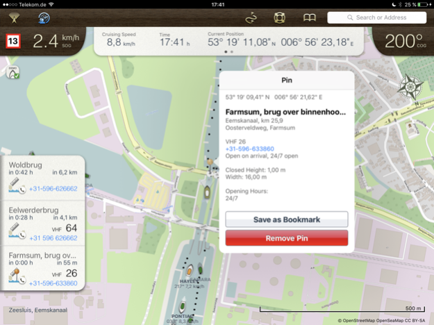
CLERANCES, OPENING HOURS AND SPEED LIMITS
Bridges and locks on the waterway ahead are displayed in a list with clearances, opening hours, VHF channels and phone numbers along with the distance and remaining driving time to get there. If bridges are to low or locks will be closed upon arrival, a warning is displayed.
FRIENDS RADAR
Even the location of your friends or flotilla is shown in the map. Find anchor position of friends to easily or keep an eye on the distance to the boots of an a convoy with the Friends Radar.
SEARCHING
Search for waters, places, addresses, coordinates and even facilities such as marinas, shops or ATMs.
You will see, Rivers & Seas is the ideal plotter for inland waters. To learn more, visit us at facebook.com/riversandseas or write us at
[email protected].
Rivers & Seas is suitable especially for Germany, Netherlands, France, Austria, Switzerland and Baltic Sea, North Sea, Balearic Islands and the Adriatic Sea. The positon of ships in ma (AIS) is useful all over the world.
The map does not show water depths. The display of clearances, speed limits and river kilometer is only available in German and Dutch inland waters.
Rivers & Seas runs on all iPads. The current GPS position can only be displayed on iPads with cellular data. Continued use of GPS running in the background can dramatically decrease battery life. For long-term use of the iPad as a chart plotter a power source is required.
Jan 30, 2021
Version 1.5.1
This update fixes the crash under iOS 14 and makes Rivers & Seas using the full screen on iPad Pro.
Minor changes:
- Problems using Dark Mode have been fixed
- Own boat is not displayed as a foreign vessel on the chart with "Show ships"
- Retina mode has been removed
- Restore Purchases is now inside "Show Ships" activation
- Activation of "Show Ships" is working again
- Smaller fixes and improvements
If you like Rivers & Seas, we'd be happy to see a review in the App Store. :-)
Previous Versions
Here you can find the changelog of Rivers & Seas since it was posted on our website on 2016-11-05 06:22:45.
The latest version is 1.5.1 and it was updated on 2024-03-29 19:29:27. See below the changes in each version.
Rivers & Seas version 1.5.1
Updated At: 2021-01-30
Changes: Jan 30, 2021
Version 1.5.1
This update fixes the crash under iOS 14 and makes Rivers & Seas using the full screen on iPad Pro.
Minor changes:
- Problems using Dark Mode have been fixed
- Own boat is not displayed as a foreign vessel on the chart with "Show ships"
- Retina mode has been removed
- Restore Purchases is now inside "Show Ships" activation
- Activation of "Show Ships" is working again
- Smaller fixes and improvements
If you like Rivers & Seas, we'd be happy to see a review in the App Store. :-)
Rivers & Seas version 1.3.9
Updated At: 2012-05-10
Disclaimer
Official App Store Link
We do not host Rivers & Seas on our servers. We did not scan it for viruses, adware, spyware or other type of malware. This app is hosted by Apple and passed their terms and conditions to be listed there. We recommend caution when installing it.
The App Store link for Rivers & Seas is provided to you by apps112.com without any warranties, representations or guarantees of any kind, so access it at your own risk.
If you have questions regarding this particular app contact the publisher directly. For questions about the functionalities of apps112.com contact us.